I'm currenty a 3rd year Ph.D. student at the Universtiy of Washington working in the Mountain Hydrology research group working under Professor Jessica Lundquist.
Summary: The persistent wet pattern has brought back up many of the lowly averages, but the low elevation locations won’t recover as we move towards a warm, wet pattern to end the month of March.
Dry/Wet, Warm/Cool Signals for the Coming Week
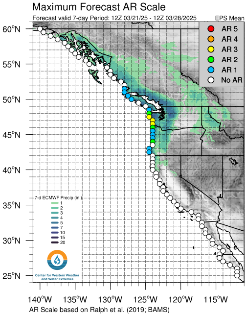
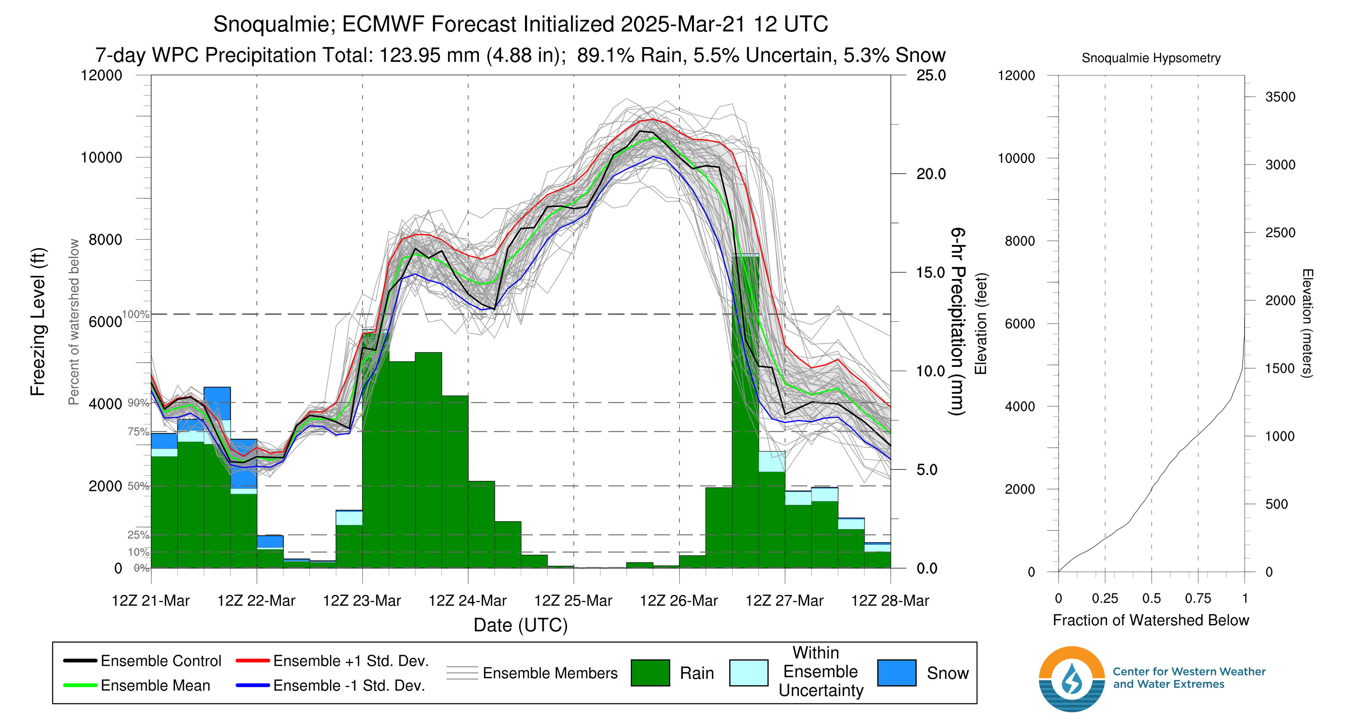
Summary: Forecast for the Snoqualamie basin for CW3E shows a freezing level right aroung 3000’ for the week, but then shooting up early next week as confidence for an AR-like feature is building.
Summary: A stormy pattern looks to linger with cold air aloft. Sun breaks will be warm things up quickly when they happen, but will be transient. Fun convection and beautiful clouds with lightning potential! Puget Sound convergence zone in play.
Washington’s snowpack is about to change to a much more seasonable state. Recent weeks have shown generally stable conditions, especially in the past week as warm-ish and relatively stable weather has persisted. Wind-effected terrain has been the primary cause for regional avalanches, but the uptick in preciptiation falling across the mountains is leading to more storm-related hazards. Crustal-interfaces, particularly one developed on 12/30, are the main sliding surfaces, with a deeper interface that could lead to some propagating larger slides on a deeper crust from the soltice. Low-elevations are still at minimal coverage, so hazards remain “early-season” (e.g. sharks…). At middle and upper-elevations, the upcoming storm cycle will start to test the interfaces between crusts and faceted layers with the overlaying new snow.
Weather
The snow-machine is starting up! A long awaited pattern change towards cooler weather is in store. Let’s go over a few details for this upcoming storm train, we’ll check back in next week to see how things unfolded.
Friday’s Frontal System
This frontal storm is arriving from the northwest this Friday evening into Saturday morning with windy weather picking up steam. Wind speeds have started to pick up this evening in the 15-20 mph range with gusts towards 30 mph in Seattle. Wind’s have not flipped yet, so front in incoming. Expecting snowfall at the passes to be around 1-2 inches per hour. Snow falling at the pass with temepratures right around freezing and strong winds.
Post-Frontal Weekend Showers and a Sunday Break
Some post-frontal weekend showers are expected to continue through the day Saturday with continued snowfall and pop-up showers with cooler air ushered in behind the front. Looks like the favored areas are in the central and southern Cascades, but we’ll see how this pans out. A reprieve is expected Sunday with generally clearer skies, but still the possibility for some mountain snows. Winds generally appear calm on Sunday, so should be a decent day for a ski.
Potent Low and Later Low-land Snow Potential
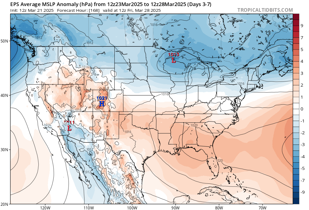
A potent low looks to arrive Monday evening with strong southwest winds, increasing temperatures. Borderline conditions persist for the pass levels, but may keep snowfall if we can keep up some easterly winds and cold air around. Moving later into the week, an arctic outbreak may be able to enhance some snowfall for the lower elevaitons. 850 mbar temps are pegged at between -8 and -11 meaning that some local low-elevation snow is a possibility! The Fraser river outflow and high-pressure, cold air looks to stream through the Fraser River gap Thursday through Friday and continue in place over the weekend. Confidence is increasing but updates are still very possible.

 Source: Tropical Tidbits
 Source: CW3E
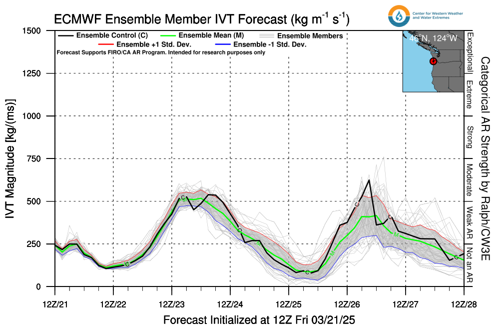 Source: CW3E